Google Map Tracing
Synvaartu Technologies Pvt. Ltd. > Google Map Tracing

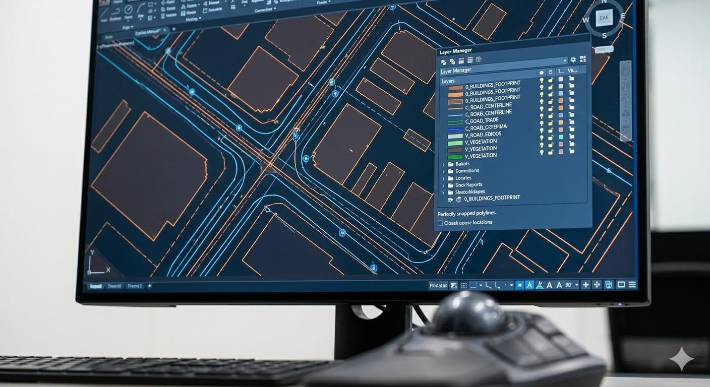
Precision Geospatial Data Extraction & Google Map Tracing
This case study highlights our ability to translate complex aerial and satellite imagery into functional technical drawings. By tracing real-world geographical data from Google Maps, we provide clients with a foundational digital layout of existing site conditions, enabling more accurate architectural planning and environmental assessments without the immediate need for expensive on-site manual surveying.

Scope of Work
Key deliverables included:
Feature Extraction: Detailed tracing of building footprints, road networks, and pavement boundaries.
Topographical Outlining: Identification and mapping of natural features, including vegetation areas and water bodies.
Infrastructure Mapping: Tracing of visible utility markers, parking lot layouts, and pedestrian walkways.
Scale Calibration: Ensuring traced data is accurately scaled to match real-world dimensions for preliminary engineering use.
Layer Management: Categorizing traced elements into organized CAD layers for easy integration into larger project files.
Technical Specifications & Details
The case study focuses on several critical technical components:
Data Source: High-resolution satellite and street-view imagery from Google Maps/Google Earth.
Output Formats: Delivery in industry-standard formats, including .DWG (AutoCAD), .DXF, or GIS-compatible files.
Precision Levels: Sharp polyline execution to ensure clean intersections and closed loops for area calculations.
Reference Accuracy: Alignment with global coordinate systems to ensure the tracing matches site-specific geolocation data.
Challenges & Solutions
Challenge: Distinguishing between permanent structures and temporary site objects or shadows in low-resolution satellite areas.
Solution: Cross-referencing top-down satellite views with street-level imagery to confirm structural boundaries and heights.
Solution: Cross-referencing top-down satellite views with street-level imagery to confirm structural boundaries and heights.
Challenge: Accounting for perspective distortion and curvature in flat map imagery.
Solution: Utilizing advanced scaling techniques and known reference points to rectify and flatten the tracing for technical accuracy.
Solution: Utilizing advanced scaling techniques and known reference points to rectify and flatten the tracing for technical accuracy.
Key Benefits Delivered
Cost-Effective Site Analysis: Provides a highly detailed "as-built" preliminary site plan at a fraction of the cost of a full ground survey.
Rapid Turnaround: Enabled the client to begin the conceptual design phase immediately using accurate digital site context.
Enhanced Visualization: Clear, layered drawings allow stakeholders to better understand the relationship between new designs and the existing environment.
Operational Reliability: Synvaartu’s quality control ensures consistent line-work and data integrity, ready for professional engineering use.
Project Summary
Synvaartu provides high-accuracy geospatial tracing services, converting satellite imagery and Google Map data into detailed, editable CAD/GIS formats. This project involved the meticulous extraction of site features, boundaries, and infrastructure layouts to support urban planning, site analysis, and logistics modeling.